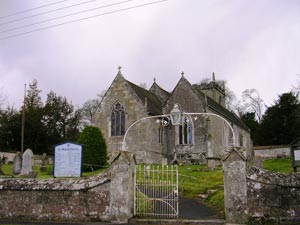
Iwerne Courtney
Also known locally as Shroton
includes Farrington and Ranston

 |
Iwerne CourtneyAlso known locally as Shroton |
 |
 |
Iwerne Courtney known
locally as Shroton is situated in a valley just off the Blandford
to Shaftesbury road. It is first mentioned in the Domesday book as
just 'Werne' by the mid 13th Century the Courtney affix had appeared
though spelt Curtney as that time. The Courtenay family, Earls of Devon
held the Manor from the early 13th Century. The other, locally used
name of Shroton derives from the Old English scir-refa & tun meaning
'the sheriff's estate', at the time of Domesday the manor belonged
to Baldwin of Exeter, sheriff of Devon. The name Shroton is preferred locally;
in his 1980 book Dorset Villages, Roland Gant stated that "I have heard only
visitors to Dorset call it Iwerne Courtney".
|
|
|
| Census |
1841 Census 1851 Census 1861 Census 1871 Census [Christel Muncaster] 1881 Census 1891 Census [John Ridout] 1901 Census 1911 Census |
| Parish Registers |
Baptisms 1731-1812, 1813-1844 [Janet Courtney] 1845-1858, 1858-1912 [Pam Sharkey] Marriages 1832-1912 [Richard Travell] Burials 1813-1892 [Pam Sharkey] |
| Postal Directories | Harrod's Directory 1865 |
| Other Records | Rectors 1295-1986 [Dorinda Miles] St Mary's Memorial Index [Jan Hibberd] |
| Photographs | Photographs [Dorinda Miles] Memorials [Dorinda Miles] Further Photographs [Julie Browning] |
| Useful Links | |
| Other information | |
| Maps | The 1891 Ordnance Survey maps of the parish can be seen at the old-maps site, just enter 'Iwerne Courtney' or 'Shroton' under place search. |
|
View Larger Map |
|
| Records held at the Dorset History Centre [Ref PE-IWC] |
Registers Christenings 1562-1912. Marriages 1563-2003. Burials 1562-1892. |
| Registration District
(for the purpose of civil registration births, marriages & deaths) |
1 Jul 1837-30 Jun 1956: Blandford 1 Jul 1956-31 Mar 1974: Poole 1 Apr 1974-17 Oct 2005: North Dorset |
Visitors to Dorset OPC
Copyright (c) 2025 Dorset OPC Project